


With the development of satellite remote sensing technology and the needs of the development of the geography of remote sensing information is widely applied in the investigation of land and resources, survey of forestry resources, ecological environment and condition monitoring of the key cities, desertification monitoring, crop yield estimation, disaster monitoring and assessment, geological and resources exploration, topographic map surveying and mapping, and many other fields. Remote sensing ground mobile terminal with its flexible and mobile deployment and the characteristics of information rapid processing, can satisfy the customers of a wide range of areas of remote sensing information acquisition and fast distribution of demand.
The main function
Ø has at the same time receive the x-band remote sensing information and the ability to send telemetry signals at the same time;
Ø possess a single pulse, program tracking tracking a variety of ways;
Ø device of motor function such as transportation, quick, quick pulling together;
Ø antenna has a key to expand and collection function;
Ø has according to the target is on the top of the situation to determine the best tilt your head tracking control procedures, to ensure that the satellite overhead can receive data;
Ø have the ability to receive different X-ray spectrum remote sensing satellite data;
Ø with standby, digital guide, SPC tracking, instruction position, automatic tracking, collecting lock, local/remote control, etc;
Ø has received and execution from the mission planning and station control management subsystem of dispatching command, business operation schedule, track number and the ability to track forecast data, when the satellite transit can automatic tracking satellite, receives the downstream data;
Ø antenna car have independent positioning, automatic car find north, antenna automatic leveling function;
Ø limit protection function: software limit, electrical limit and mechanical buffer multistage protection;
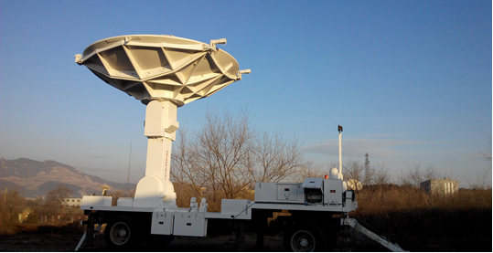
Product pictures
主要技术指标
| 天线频段 | X频段:8000MHz~9000MHz(接收、跟踪) |
| 天线形式 | 4.5米环焦双反射面天线 |
| 天线增益 | G/T≥{48+20lg(F(GHz)/8.2)}dBi |
| G/T值 | ≥28.2+20lg(f/f0)dB/K(f0=8.2GHz) |
| 极化方式 | RHCP/LHCP同时工作 |
| 第一旁瓣 | ≤-15dB |
| 天线座驾型式 | 采用方位、俯仰加第三轴(倾斜轴) |
| 天线转动范围 | 方位:±320° 俯仰:-1°~181° 第三轴:±7°(相对垂直位置) |
| 角速度 | 方位轴:0.01~20°/s;俯仰轴:0.01~10°/s |
| 角加速度 | 方位轴:0.001~10°/ s2 ;俯仰轴:0.001~5°/ s2 |
| 指向精度 | ≤0.15°(风速≤20m/s) |
| 工作温度 | -40℃~+60℃(室外设备),10℃~40℃(室内设备) |
| 相对湿度 | 0~100%(40℃)(室外设备),30%~85%(30℃)(室内设备) |
| 抗风性能 | 5级时正常工作 |
| 电源供应 | 电压:220V AC±10%,380V AC±10%;频率:50Hz±5%; 类型:单相 |
| 可靠性 | MTBF≥800小时;MTTR≤1小时 |